|
|
|||||||||||||||||
| Point ID: 6587 | Downloads | Plots | Site Data | Code: 9316 |
|
|
|||||||||||||||||
| Download | |
|---|---|
| Site Descriptor Information | Site Time Series Data |
| Link to all available data | |
| View: | Time Series | All |
| Units: | mm |
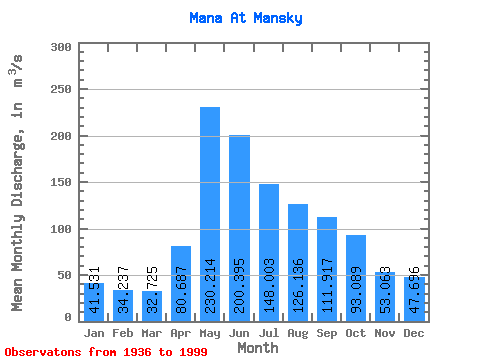
| Statistic | Jan | Feb | Mar | Apr | May | Jun | Jul | Aug | Sep | Oct | Nov | Dec | Annual |
|---|---|---|---|---|---|---|---|---|---|---|---|---|---|
| Mean | 41.53 | 34.24 | 32.73 | 80.69 | 230.21 | 200.40 | 148.00 | 126.14 | 111.92 | 93.09 | 53.06 | 47.70 | 99.71 |
| Standard Deviation | 9.29 | 7.16 | 6.83 | 34.82 | 69.70 | 65.83 | 50.06 | 47.53 | 29.88 | 26.65 | 17.02 | 11.36 | 18.10 |
| Min | 25.80 | 22.10 | 17.70 | 25.70 | 127.00 | 87.40 | 75.40 | 56.70 | 54.10 | 45.50 | 28.50 | 28.40 | 62.86 |
| Max | 73.30 | 62.30 | 58.40 | 165.00 | 479.00 | 400.00 | 327.00 | 292.00 | 185.00 | 181.00 | 106.00 | 96.80 | 144.88 |
| Coefficient of Variation | 0.22 | 0.21 | 0.21 | 0.43 | 0.30 | 0.33 | 0.34 | 0.38 | 0.27 | 0.29 | 0.32 | 0.24 | 0.18 |
 Return to R-Arctic Net Home Page