|
|
|||||||||||||||||
| Point ID: 6556 | Downloads | Plots | Site Data | Code: 9130 |
|
|
|||||||||||||||||
| Download | |
|---|---|
| Site Descriptor Information | Site Time Series Data |
| Link to all available data | |
| View: | Time Series | All |
| Units: | mm |
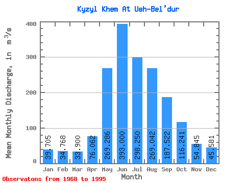
| Statistic | Jan | Feb | Mar | Apr | May | Jun | Jul | Aug | Sep | Oct | Nov | Dec | Annual |
|---|---|---|---|---|---|---|---|---|---|---|---|---|---|
| Mean | 39.70 | 34.77 | 33.90 | 76.06 | 269.29 | 393.00 | 298.25 | 269.04 | 187.52 | 116.24 | 54.84 | 45.58 | 148.41 |
| Standard Deviation | 7.03 | 6.65 | 6.18 | 84.92 | 101.86 | 106.04 | 88.91 | 65.94 | 37.33 | 24.88 | 13.93 | 8.74 | 22.44 |
| Min | 20.60 | 19.00 | 16.80 | 31.40 | 148.00 | 190.00 | 179.00 | 145.00 | 121.00 | 85.40 | 29.80 | 22.60 | 104.69 |
| Max | 50.20 | 46.60 | 44.80 | 436.00 | 533.00 | 629.00 | 533.00 | 380.00 | 266.00 | 196.00 | 80.50 | 61.40 | 200.77 |
| Coefficient of Variation | 0.18 | 0.19 | 0.18 | 1.12 | 0.38 | 0.27 | 0.30 | 0.24 | 0.20 | 0.21 | 0.25 | 0.19 | 0.15 |
 Return to R-Arctic Net Home Page