|
|
|||||||||||||||||
| Point ID: 6548 | Downloads | Plots | Site Data | Other Close Sites | Code: 9116 |
|
|
|||||||||||||||||
| Download | |
|---|---|
| Site Descriptor Information | Site Time Series Data |
| Link to all available data | |
| View: | Time Series | All |
| Units: | mm |
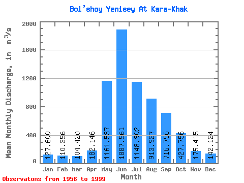
| Statistic | Jan | Feb | Mar | Apr | May | Jun | Jul | Aug | Sep | Oct | Nov | Dec | Annual |
|---|---|---|---|---|---|---|---|---|---|---|---|---|---|
| Mean | 127.60 | 110.36 | 104.42 | 182.15 | 1161.54 | 1887.56 | 1148.90 | 913.93 | 716.76 | 427.76 | 175.41 | 142.12 | 591.54 |
| Standard Deviation | 24.21 | 26.97 | 30.94 | 83.70 | 314.01 | 549.33 | 339.11 | 263.79 | 177.10 | 102.43 | 39.30 | 27.68 | 93.97 |
| Min | 84.20 | 69.50 | 69.20 | 101.00 | 655.00 | 1040.00 | 618.00 | 477.00 | 307.00 | 238.00 | 111.00 | 88.10 | 392.83 |
| Max | 185.00 | 170.00 | 186.00 | 491.00 | 1930.00 | 3390.00 | 1780.00 | 1540.00 | 1110.00 | 836.00 | 273.00 | 215.00 | 832.17 |
| Coefficient of Variation | 0.19 | 0.24 | 0.30 | 0.46 | 0.27 | 0.29 | 0.29 | 0.29 | 0.25 | 0.24 | 0.22 | 0.20 | 0.16 |
| Other Close Sites | ||||||
|---|---|---|---|---|---|---|
| PointID | Latitude | Longitude | Drainage Area | Source | Name | |
| 6537 | "Yenisey at Kyizyil" | 51.72 | 320529 | SHI | 3486.00 | |
| 6555 | "Maly Yenisey At Kyzyl" | 51.72 | 327799 | SHI | 2.00 | |
 Return to R-Arctic Net Home Page