|
|
|||||||||||||||||
| Point ID: 6544 | Downloads | Plots | Site Data | Code: 9092 |
|
|
|||||||||||||||||
| Download | |
|---|---|
| Site Descriptor Information | Site Time Series Data |
| Link to all available data | |
| View: | Time Series | All |
| Units: | mm |
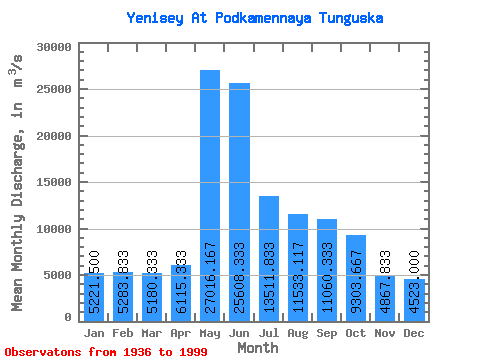
| Statistic | Jan | Feb | Mar | Apr | May | Jun | Jul | Aug | Sep | Oct | Nov | Dec | Annual |
|---|---|---|---|---|---|---|---|---|---|---|---|---|---|
| Mean | 5221.50 | 5283.83 | 5180.33 | 6115.33 | 27016.17 | 25608.33 | 13511.83 | 11533.12 | 11060.33 | 9303.67 | 4867.83 | 4523.00 | 10768.77 |
| Standard Deviation | 1426.80 | 1792.00 | 2071.62 | 2733.29 | 5092.38 | 7068.34 | 3159.55 | 2987.88 | 2180.20 | 1319.89 | 1415.25 | 1180.73 | 931.30 |
| Min | 2720.00 | 2450.00 | 2290.00 | 2180.00 | 16700.00 | 13100.00 | 9370.00 | 977.00 | 1290.00 | 5940.00 | 2480.00 | 2740.00 | 8639.17 |
| Max | 7790.00 | 8460.00 | 8910.00 | 16100.00 | 39000.00 | 51400.00 | 22200.00 | 17100.00 | 15300.00 | 13000.00 | 8940.00 | 7080.00 | 12637.50 |
| Coefficient of Variation | 0.27 | 0.34 | 0.40 | 0.45 | 0.19 | 0.28 | 0.23 | 0.26 | 0.20 | 0.14 | 0.29 | 0.26 | 0.09 |
 Return to R-Arctic Net Home Page