|
|
|||||||||||||||||
| Point ID: 6525 | Downloads | Plots | Site Data | Code: 8365 |
|
|
|||||||||||||||||
| Download | |
|---|---|
| Site Descriptor Information | Site Time Series Data |
| Link to all available data | |
| View: | Time Series | All |
| Units: | mm |
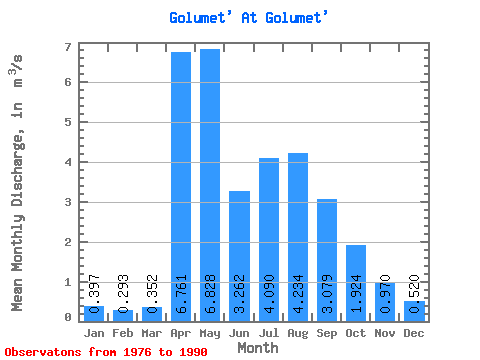
| Statistic | Jan | Feb | Mar | Apr | May | Jun | Jul | Aug | Sep | Oct | Nov | Dec | Annual |
|---|---|---|---|---|---|---|---|---|---|---|---|---|---|
| Mean | 0.40 | 0.29 | 0.35 | 6.76 | 6.83 | 3.26 | 4.09 | 4.23 | 3.08 | 1.92 | 0.97 | 0.52 | 2.79 |
| Standard Deviation | 0.20 | 0.15 | 0.25 | 3.30 | 3.20 | 1.57 | 3.06 | 2.52 | 1.86 | 0.68 | 0.34 | 0.23 | 0.83 |
| Min | 0.10 | 0.03 | 0.04 | 2.38 | 2.06 | 1.14 | 1.29 | 1.22 | 0.92 | 0.86 | 0.33 | 0.04 | 1.59 |
| Max | 0.88 | 0.66 | 0.96 | 12.80 | 11.90 | 6.14 | 11.20 | 8.85 | 7.06 | 3.27 | 1.72 | 0.98 | 4.07 |
| Coefficient of Variation | 0.50 | 0.51 | 0.72 | 0.49 | 0.47 | 0.48 | 0.75 | 0.59 | 0.60 | 0.35 | 0.35 | 0.44 | 0.30 |
 Return to R-Arctic Net Home Page