|
|
|||||||||||||||||
| Point ID: 6510 | Downloads | Plots | Site Data | Code: 8327 |
|
|
|||||||||||||||||
| Download | |
|---|---|
| Site Descriptor Information | Site Time Series Data |
| Link to all available data | |
| View: | Time Series | All |
| Units: | mm |
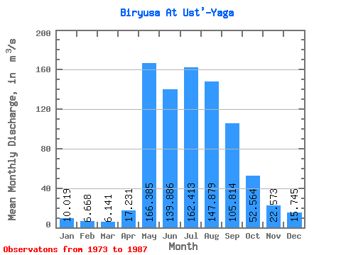
| Statistic | Jan | Feb | Mar | Apr | May | Jun | Jul | Aug | Sep | Oct | Nov | Dec | Annual |
|---|---|---|---|---|---|---|---|---|---|---|---|---|---|
| Mean | 10.02 | 6.67 | 6.14 | 17.23 | 166.38 | 139.89 | 162.41 | 147.88 | 105.81 | 52.56 | 22.57 | 15.74 | 74.47 |
| Standard Deviation | 3.47 | 3.31 | 3.36 | 21.26 | 39.40 | 57.18 | 67.98 | 60.19 | 42.61 | 10.84 | 5.81 | 5.79 | 11.70 |
| Min | 4.27 | 2.96 | 2.98 | 4.92 | 111.00 | 77.80 | 58.90 | 29.50 | 59.60 | 39.30 | 16.00 | 6.41 | 50.97 |
| Max | 17.10 | 14.60 | 12.80 | 82.90 | 240.00 | 268.00 | 296.00 | 236.00 | 220.00 | 68.60 | 32.60 | 27.40 | 91.74 |
| Coefficient of Variation | 0.35 | 0.50 | 0.55 | 1.23 | 0.24 | 0.41 | 0.42 | 0.41 | 0.40 | 0.21 | 0.26 | 0.37 | 0.16 |
 Return to R-Arctic Net Home Page