|
|
|||||||||||||||||
| Point ID: 6504 | Downloads | Plots | Site Data | Code: 8309 |
|
|
|||||||||||||||||
| Download | |
|---|---|
| Site Descriptor Information | Site Time Series Data |
| Link to all available data | |
| View: | Time Series | All |
| Units: | mm |
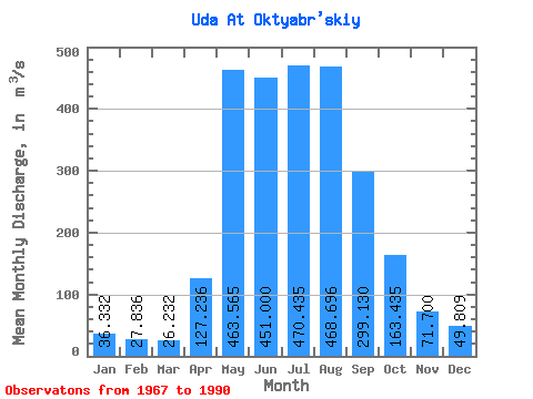
| Statistic | Jan | Feb | Mar | Apr | May | Jun | Jul | Aug | Sep | Oct | Nov | Dec | Annual |
|---|---|---|---|---|---|---|---|---|---|---|---|---|---|
| Mean | 36.33 | 27.84 | 26.23 | 127.24 | 463.56 | 451.00 | 470.44 | 468.70 | 299.13 | 163.44 | 71.70 | 49.81 | 218.90 |
| Standard Deviation | 8.30 | 6.62 | 6.84 | 76.93 | 140.84 | 115.14 | 178.24 | 182.01 | 95.17 | 38.22 | 16.34 | 8.72 | 40.00 |
| Min | 16.40 | 15.80 | 16.90 | 42.80 | 256.00 | 255.00 | 243.00 | 248.00 | 160.00 | 105.00 | 47.60 | 34.80 | 164.28 |
| Max | 52.80 | 39.70 | 40.90 | 307.00 | 675.00 | 790.00 | 895.00 | 1000.00 | 529.00 | 268.00 | 110.00 | 67.90 | 293.11 |
| Coefficient of Variation | 0.23 | 0.24 | 0.26 | 0.60 | 0.30 | 0.26 | 0.38 | 0.39 | 0.32 | 0.23 | 0.23 | 0.17 | 0.18 |
 Return to R-Arctic Net Home Page