|
|
|||||||||||||||||
| Point ID: 6500 | Downloads | Plots | Site Data | Code: 8296 |
|
|
|||||||||||||||||
| Download | |
|---|---|
| Site Descriptor Information | Site Time Series Data |
| Link to all available data | |
| View: | Time Series | All |
| Units: | mm |
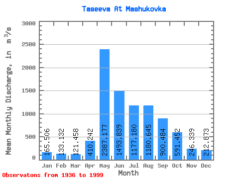
| Statistic | Jan | Feb | Mar | Apr | May | Jun | Jul | Aug | Sep | Oct | Nov | Dec | Annual |
|---|---|---|---|---|---|---|---|---|---|---|---|---|---|
| Mean | 165.51 | 133.13 | 121.46 | 410.24 | 2387.18 | 1493.84 | 1177.18 | 1180.64 | 900.48 | 591.45 | 246.34 | 212.87 | 751.61 |
| Standard Deviation | 35.05 | 28.06 | 26.87 | 335.56 | 730.41 | 415.19 | 380.44 | 417.90 | 233.41 | 155.20 | 66.03 | 45.40 | 132.36 |
| Min | 78.40 | 70.70 | 57.70 | 115.00 | 385.00 | 763.00 | 612.00 | 520.00 | 499.00 | 355.00 | 131.00 | 93.10 | 474.18 |
| Max | 261.00 | 213.00 | 183.00 | 1410.00 | 4450.00 | 2910.00 | 2170.00 | 2670.00 | 1500.00 | 1060.00 | 432.00 | 317.00 | 1028.00 |
| Coefficient of Variation | 0.21 | 0.21 | 0.22 | 0.82 | 0.31 | 0.28 | 0.32 | 0.35 | 0.26 | 0.26 | 0.27 | 0.21 | 0.18 |
 Return to R-Arctic Net Home Page