|
|
|||||||||||||||||
| Point ID: 6497 | Downloads | Plots | Site Data | Code: 8290 |
|
|
|||||||||||||||||
| Download | |
|---|---|
| Site Descriptor Information | Site Time Series Data |
| Link to all available data | |
| View: | Time Series | All |
| Units: | mm |
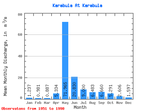
| Statistic | Jan | Feb | Mar | Apr | May | Jun | Jul | Aug | Sep | Oct | Nov | Dec | Annual |
|---|---|---|---|---|---|---|---|---|---|---|---|---|---|
| Mean | 1.24 | 0.98 | 0.89 | 5.33 | 71.97 | 20.83 | 9.00 | 6.48 | 6.66 | 5.29 | 2.61 | 1.60 | 11.07 |
| Standard Deviation | 0.79 | 0.66 | 0.76 | 7.08 | 22.25 | 10.31 | 4.60 | 3.02 | 2.92 | 2.15 | 1.21 | 0.91 | 2.90 |
| Min | 0.31 | 0.22 | 0.08 | 0.36 | 24.10 | 8.76 | 4.12 | 1.82 | 2.86 | 2.20 | 1.03 | 0.50 | 4.95 |
| Max | 3.74 | 3.28 | 3.44 | 34.50 | 121.00 | 54.70 | 24.60 | 19.90 | 15.10 | 12.50 | 6.67 | 4.00 | 18.17 |
| Coefficient of Variation | 0.64 | 0.67 | 0.85 | 1.33 | 0.31 | 0.49 | 0.51 | 0.47 | 0.44 | 0.41 | 0.46 | 0.57 | 0.26 |
 Return to R-Arctic Net Home Page