|
|
|||||||||||||||||
| Point ID: 6490 | Downloads | Plots | Site Data | Code: 8256 |
|
|
|||||||||||||||||
| Download | |
|---|---|
| Site Descriptor Information | Site Time Series Data |
| Link to all available data | |
| View: | Time Series | All |
| Units: | mm |
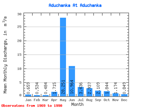
| Statistic | Jan | Feb | Mar | Apr | May | Jun | Jul | Aug | Sep | Oct | Nov | Dec | Annual |
|---|---|---|---|---|---|---|---|---|---|---|---|---|---|
| Mean | 0.66 | 0.53 | 0.48 | 1.71 | 28.25 | 10.96 | 3.44 | 2.94 | 2.11 | 1.84 | 1.17 | 0.85 | 4.57 |
| Standard Deviation | 0.27 | 0.24 | 0.21 | 1.79 | 12.15 | 6.19 | 2.02 | 4.64 | 0.90 | 0.67 | 0.38 | 0.30 | 1.65 |
| Min | 0.27 | 0.22 | 0.19 | 0.45 | 8.93 | 3.73 | 1.28 | 0.58 | 0.73 | 0.59 | 0.32 | 0.30 | 2.18 |
| Max | 1.52 | 1.32 | 1.13 | 6.95 | 57.80 | 28.20 | 9.94 | 23.30 | 3.83 | 3.54 | 1.95 | 1.63 | 8.49 |
| Coefficient of Variation | 0.41 | 0.45 | 0.43 | 1.04 | 0.43 | 0.56 | 0.59 | 1.58 | 0.42 | 0.36 | 0.32 | 0.36 | 0.36 |
 Return to R-Arctic Net Home Page