|
|
|||||||||||||||||
| Point ID: 6489 | Downloads | Plots | Site Data | Code: 8254 |
|
|
|||||||||||||||||
| Download | |
|---|---|
| Site Descriptor Information | Site Time Series Data |
| Link to all available data | |
| View: | Time Series | All |
| Units: | mm |
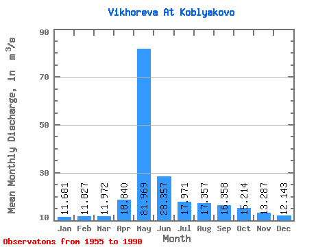
| Statistic | Jan | Feb | Mar | Apr | May | Jun | Jul | Aug | Sep | Oct | Nov | Dec | Annual |
|---|---|---|---|---|---|---|---|---|---|---|---|---|---|
| Mean | 11.68 | 11.83 | 11.97 | 18.84 | 81.97 | 28.36 | 17.97 | 17.36 | 16.36 | 15.21 | 13.29 | 12.14 | 21.48 |
| Standard Deviation | 5.66 | 5.68 | 5.64 | 10.58 | 24.91 | 8.60 | 6.56 | 6.85 | 6.33 | 5.84 | 5.99 | 5.63 | 5.69 |
| Min | 2.39 | 2.44 | 2.48 | 4.09 | 40.90 | 13.30 | 4.62 | 5.29 | 4.66 | 4.21 | 3.15 | 2.53 | 8.28 |
| Max | 22.30 | 19.90 | 20.10 | 47.20 | 149.00 | 52.20 | 30.00 | 35.30 | 31.90 | 26.50 | 22.70 | 20.90 | 32.33 |
| Coefficient of Variation | 0.48 | 0.48 | 0.47 | 0.56 | 0.30 | 0.30 | 0.36 | 0.40 | 0.39 | 0.38 | 0.45 | 0.46 | 0.27 |
 Return to R-Arctic Net Home Page