|
|
|||||||||||||||||
| Point ID: 648 | Downloads | Plots | Site Data | Code: 07BB005 |
|
|
|||||||||||||||||
| Download | |
|---|---|
| Site Descriptor Information | Site Time Series Data |
| Link to all available data | |
| View: | Time Series | All |
| Units: | mm |
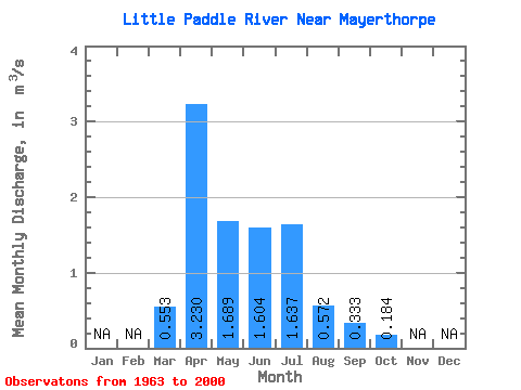
| Statistic | Jan | Feb | Mar | Apr | May | Jun | Jul | Aug | Sep | Oct | Nov | Dec | Annual |
|---|---|---|---|---|---|---|---|---|---|---|---|---|---|
| Mean | 0.55 | 3.23 | 1.69 | 1.60 | 1.64 | 0.57 | 0.33 | 0.18 | |||||
| Standard Deviation | 0.65 | 3.32 | 1.59 | 1.81 | 2.07 | 1.25 | 0.50 | 0.18 | |||||
| Min | 0.00 | 0.17 | 0.09 | 0.02 | 0.00 | 0.00 | 0.00 | 0.00 | |||||
| Max | 2.14 | 17.30 | 6.70 | 7.48 | 10.80 | 7.60 | 2.60 | 0.76 | |||||
| Coefficient of Variation | 1.17 | 1.03 | 0.94 | 1.13 | 1.26 | 2.19 | 1.50 | 0.95 |
 Return to R-Arctic Net Home Page