|
|
|||||||||||||||||
| Point ID: 6467 | Downloads | Plots | Site Data | Code: 8155 |
|
|
|||||||||||||||||
| Download | |
|---|---|
| Site Descriptor Information | Site Time Series Data |
| Link to all available data | |
| View: | Time Series | All |
| Units: | mm |
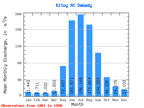
| Statistic | Jan | Feb | Mar | Apr | May | Jun | Jul | Aug | Sep | Oct | Nov | Dec | Annual |
|---|---|---|---|---|---|---|---|---|---|---|---|---|---|
| Mean | 11.44 | 8.71 | 9.03 | 12.85 | 73.01 | 181.57 | 196.15 | 171.66 | 104.33 | 46.13 | 24.07 | 17.03 | 69.91 |
| Standard Deviation | 2.72 | 1.50 | 1.30 | 4.22 | 23.75 | 52.55 | 41.77 | 46.67 | 26.85 | 8.90 | 4.70 | 3.49 | 9.88 |
| Min | 6.70 | 5.47 | 6.24 | 6.93 | 27.00 | 104.00 | 117.00 | 99.60 | 70.60 | 30.20 | 16.10 | 11.50 | 53.35 |
| Max | 16.70 | 11.30 | 12.90 | 24.30 | 119.00 | 309.00 | 296.00 | 309.00 | 175.00 | 61.40 | 35.10 | 22.80 | 86.83 |
| Coefficient of Variation | 0.24 | 0.17 | 0.14 | 0.33 | 0.33 | 0.29 | 0.21 | 0.27 | 0.26 | 0.19 | 0.20 | 0.20 | 0.14 |
 Return to R-Arctic Net Home Page