|
|
|||||||||||||||||
| Point ID: 6459 | Downloads | Plots | Site Data | Code: 8091 |
|
|
|||||||||||||||||
| Download | |
|---|---|
| Site Descriptor Information | Site Time Series Data |
| Link to all available data | |
| View: | Time Series | All |
| Units: | mm |
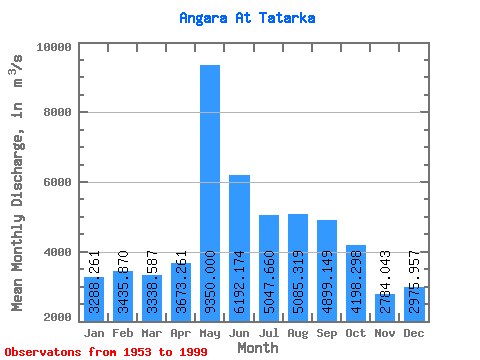
| Statistic | Jan | Feb | Mar | Apr | May | Jun | Jul | Aug | Sep | Oct | Nov | Dec | Annual |
|---|---|---|---|---|---|---|---|---|---|---|---|---|---|
| Mean | 3288.26 | 3435.87 | 3338.59 | 3673.26 | 9350.00 | 6192.17 | 5047.66 | 5085.32 | 4899.15 | 4198.30 | 2784.04 | 2975.96 | 4518.11 |
| Standard Deviation | 848.01 | 1072.90 | 1049.15 | 1332.03 | 1490.45 | 1296.35 | 775.70 | 708.55 | 681.18 | 554.85 | 687.88 | 830.91 | 449.64 |
| Min | 1490.00 | 1540.00 | 1530.00 | 1570.00 | 5950.00 | 4240.00 | 4190.00 | 4230.00 | 3680.00 | 2370.00 | 920.00 | 1180.00 | 3616.67 |
| Max | 4790.00 | 5300.00 | 5280.00 | 7800.00 | 12600.00 | 11000.00 | 7160.00 | 7420.00 | 6830.00 | 5110.00 | 4170.00 | 4950.00 | 5520.83 |
| Coefficient of Variation | 0.26 | 0.31 | 0.31 | 0.36 | 0.16 | 0.21 | 0.15 | 0.14 | 0.14 | 0.13 | 0.25 | 0.28 | 0.10 |
 Return to R-Arctic Net Home Page