|
|
|||||||||||||||||
| Point ID: 6458 | Downloads | Plots | Site Data | Code: 8084 |
|
|
|||||||||||||||||
| Download | |
|---|---|
| Site Descriptor Information | Site Time Series Data |
| Link to all available data | |
| View: | Time Series | All |
| Units: | mm |
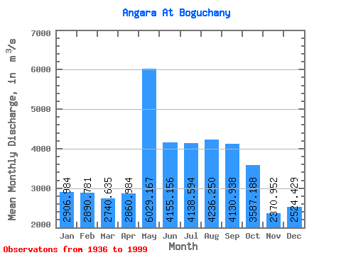
| Statistic | Jan | Feb | Mar | Apr | May | Jun | Jul | Aug | Sep | Oct | Nov | Dec | Annual |
|---|---|---|---|---|---|---|---|---|---|---|---|---|---|
| Mean | 2906.98 | 2890.78 | 2740.64 | 2860.98 | 6029.17 | 4155.16 | 4138.59 | 4236.25 | 4130.94 | 3587.19 | 2370.95 | 2524.43 | 3499.83 |
| Standard Deviation | 835.06 | 939.50 | 963.59 | 1032.67 | 1165.98 | 837.81 | 1063.86 | 1038.54 | 895.41 | 726.99 | 734.73 | 700.46 | 431.19 |
| Min | 1160.00 | 1220.00 | 1150.00 | 962.00 | 3670.00 | 2660.00 | 2880.00 | 2890.00 | 2910.00 | 1210.00 | 580.00 | 899.00 | 2619.17 |
| Max | 5230.00 | 5060.00 | 4650.00 | 4880.00 | 9000.00 | 6550.00 | 7450.00 | 6820.00 | 6330.00 | 5400.00 | 4010.00 | 4230.00 | 4402.50 |
| Coefficient of Variation | 0.29 | 0.33 | 0.35 | 0.36 | 0.19 | 0.20 | 0.26 | 0.24 | 0.22 | 0.20 | 0.31 | 0.28 | 0.12 |
 Return to R-Arctic Net Home Page