|
|
|||||||||||||||||
| Point ID: 6443 | Downloads | Plots | Site Data | Code: 7137 |
|
|
|||||||||||||||||
| Download | |
|---|---|
| Site Descriptor Information | Site Time Series Data |
| Link to all available data | |
| View: | Time Series | All |
| Units: | mm |
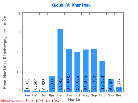
| Statistic | Jan | Feb | Mar | Apr | May | Jun | Jul | Aug | Sep | Oct | Nov | Dec | Annual |
|---|---|---|---|---|---|---|---|---|---|---|---|---|---|
| Mean | 1.03 | 0.60 | 0.54 | 7.81 | 31.49 | 21.54 | 20.00 | 21.24 | 21.75 | 15.38 | 6.40 | 2.57 | 12.66 |
| Standard Deviation | 0.63 | 0.57 | 0.56 | 6.38 | 14.98 | 17.64 | 14.80 | 14.29 | 13.71 | 8.55 | 3.76 | 1.70 | 6.22 |
| Min | 0.00 | 0.00 | 0.00 | 0.35 | 9.68 | 6.27 | 5.61 | 5.91 | 6.18 | 5.16 | 2.01 | 0.51 | 4.02 |
| Max | 2.84 | 2.06 | 2.05 | 28.70 | 67.80 | 94.00 | 88.30 | 57.30 | 59.50 | 42.70 | 21.40 | 9.30 | 30.31 |
| Coefficient of Variation | 0.61 | 0.94 | 1.03 | 0.82 | 0.48 | 0.82 | 0.74 | 0.67 | 0.63 | 0.56 | 0.59 | 0.66 | 0.49 |
 Return to R-Arctic Net Home Page