|
|
|||||||||||||||||
| Point ID: 6434 | Downloads | Plots | Site Data | Code: 7117 |
|
|
|||||||||||||||||
| Download | |
|---|---|
| Site Descriptor Information | Site Time Series Data |
| Link to all available data | |
| View: | Time Series | All |
| Units: | mm |
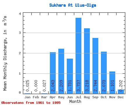
| Statistic | Jan | Feb | Mar | Apr | May | Jun | Jul | Aug | Sep | Oct | Nov | Dec | Annual |
|---|---|---|---|---|---|---|---|---|---|---|---|---|---|
| Mean | 0.03 | 0.00 | 0.03 | 2.04 | 2.21 | 1.73 | 3.74 | 3.22 | 2.74 | 2.07 | 1.10 | 0.20 | 1.58 |
| Standard Deviation | 0.12 | 0.00 | 0.06 | 1.74 | 1.56 | 1.52 | 3.23 | 2.05 | 1.39 | 1.09 | 0.69 | 0.20 | 0.79 |
| Min | 0.00 | 0.00 | 0.00 | 0.18 | 0.33 | 0.04 | 0.42 | 0.57 | 0.58 | 0.44 | 0.18 | 0.00 | 0.28 |
| Max | 0.72 | 0.00 | 0.26 | 6.81 | 6.20 | 5.78 | 13.00 | 9.49 | 5.74 | 4.85 | 2.65 | 0.72 | 3.18 |
| Coefficient of Variation | 4.80 | 2.11 | 0.85 | 0.71 | 0.88 | 0.86 | 0.64 | 0.51 | 0.52 | 0.63 | 1.00 | 0.50 |
 Return to R-Arctic Net Home Page