|
|
|||||||||||||||||
| Point ID: 6426 | Downloads | Plots | Site Data | Code: 7093 |
|
|
|||||||||||||||||
| Download | |
|---|---|
| Site Descriptor Information | Site Time Series Data |
| Link to all available data | |
| View: | Time Series | All |
| Units: | mm |
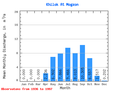
| Statistic | Jan | Feb | Mar | Apr | May | Jun | Jul | Aug | Sep | Oct | Nov | Dec | Annual |
|---|---|---|---|---|---|---|---|---|---|---|---|---|---|
| Mean | 0.00 | 0.00 | 0.00 | 2.24 | 6.90 | 7.87 | 9.47 | 8.01 | 10.30 | 6.56 | 1.52 | 0.20 | 4.38 |
| Standard Deviation | 0.00 | 0.00 | 0.00 | 3.14 | 6.33 | 10.63 | 9.02 | 7.92 | 9.99 | 6.08 | 1.58 | 0.29 | 3.61 |
| Min | 0.00 | 0.00 | 0.00 | 0.00 | 0.34 | 0.17 | 0.14 | 0.06 | 0.09 | 0.05 | 0.00 | 0.00 | 0.16 |
| Max | 0.00 | 0.00 | 0.00 | 14.20 | 26.00 | 45.00 | 30.60 | 29.60 | 36.70 | 20.80 | 4.43 | 1.00 | 12.59 |
| Coefficient of Variation | 1.40 | 0.92 | 1.35 | 0.95 | 0.99 | 0.97 | 0.93 | 1.04 | 1.44 | 0.82 |
 Return to R-Arctic Net Home Page