|
|
|||||||||||||||||
| Point ID: 6425 | Downloads | Plots | Site Data | Code: 7092 |
|
|
|||||||||||||||||
| Download | |
|---|---|
| Site Descriptor Information | Site Time Series Data |
| Link to all available data | |
| View: | Time Series | All |
| Units: | mm |
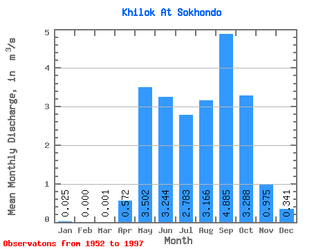
| Statistic | Jan | Feb | Mar | Apr | May | Jun | Jul | Aug | Sep | Oct | Nov | Dec | Annual |
|---|---|---|---|---|---|---|---|---|---|---|---|---|---|
| Mean | 0.03 | 0.00 | 0.00 | 0.57 | 3.50 | 3.24 | 2.78 | 3.17 | 4.88 | 3.29 | 0.97 | 0.34 | 2.55 |
| Standard Deviation | 0.06 | 0.00 | 0.01 | 1.01 | 4.32 | 6.17 | 5.22 | 4.77 | 7.99 | 4.17 | 1.20 | 0.50 | 3.01 |
| Min | 0.00 | 0.00 | 0.00 | 0.00 | 0.00 | 0.01 | 0.01 | 0.00 | 0.00 | 0.03 | 0.00 | 0.00 | 0.15 |
| Max | 0.24 | 0.00 | 0.02 | 4.76 | 21.80 | 31.20 | 27.80 | 17.90 | 36.40 | 17.30 | 4.94 | 2.07 | 11.06 |
| Coefficient of Variation | 2.41 | 4.36 | 1.76 | 1.23 | 1.90 | 1.88 | 1.51 | 1.64 | 1.27 | 1.23 | 1.47 | 1.18 |
 Return to R-Arctic Net Home Page