|
|
|||||||||||||||||
| Point ID: 642 | Downloads | Plots | Site Data | Code: 07BA002 |
|
|
|||||||||||||||||
| Download | |
|---|---|
| Site Descriptor Information | Site Time Series Data |
| Link to all available data | |
| View: | Time Series | All |
| Units: | mm |
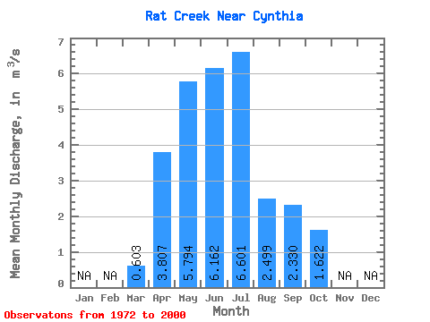
| Statistic | Jan | Feb | Mar | Apr | May | Jun | Jul | Aug | Sep | Oct | Nov | Dec | Annual |
|---|---|---|---|---|---|---|---|---|---|---|---|---|---|
| Mean | 0.60 | 3.81 | 5.79 | 6.16 | 6.60 | 2.50 | 2.33 | 1.62 | |||||
| Standard Deviation | 0.55 | 2.80 | 4.46 | 5.62 | 5.91 | 2.14 | 2.22 | 1.13 | |||||
| Min | 0.10 | 0.68 | 0.38 | 1.58 | 0.42 | 0.21 | 0.43 | 0.42 | |||||
| Max | 3.15 | 11.70 | 17.80 | 22.40 | 30.60 | 9.06 | 7.78 | 4.70 | |||||
| Coefficient of Variation | 0.91 | 0.74 | 0.77 | 0.91 | 0.90 | 0.85 | 0.95 | 0.69 |
 Return to R-Arctic Net Home Page