|
|
|||||||||||||||||
| Point ID: 6414 | Downloads | Plots | Site Data | Code: 7056 |
|
|
|||||||||||||||||
| Download | |
|---|---|
| Site Descriptor Information | Site Time Series Data |
| Link to all available data | |
| View: | Time Series | All |
| Units: | mm |
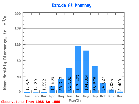
| Statistic | Jan | Feb | Mar | Apr | May | Jun | Jul | Aug | Sep | Oct | Nov | Dec | Annual |
|---|---|---|---|---|---|---|---|---|---|---|---|---|---|
| Mean | 1.70 | 1.13 | 1.59 | 17.61 | 33.74 | 61.38 | 117.43 | 104.88 | 66.58 | 24.83 | 8.04 | 3.41 | 36.06 |
| Standard Deviation | 1.16 | 0.79 | 0.94 | 37.91 | 17.25 | 39.01 | 67.49 | 54.39 | 42.79 | 10.01 | 3.98 | 2.01 | 12.02 |
| Min | 0.17 | 0.09 | 0.01 | 2.30 | 15.00 | 10.50 | 25.20 | 20.20 | 17.50 | 12.10 | 0.47 | 0.18 | 16.79 |
| Max | 4.92 | 3.44 | 3.76 | 271.00 | 98.50 | 201.00 | 324.00 | 232.00 | 222.00 | 52.60 | 16.80 | 8.43 | 68.85 |
| Coefficient of Variation | 0.68 | 0.70 | 0.59 | 2.15 | 0.51 | 0.64 | 0.57 | 0.52 | 0.64 | 0.40 | 0.49 | 0.59 | 0.33 |
 Return to R-Arctic Net Home Page