|
|
|||||||||||||||||
| Point ID: 6407 | Downloads | Plots | Site Data | Code: 7031 |
|
|
|||||||||||||||||
| Download | |
|---|---|
| Site Descriptor Information | Site Time Series Data |
| Link to all available data | |
| View: | Time Series | All |
| Units: | mm |
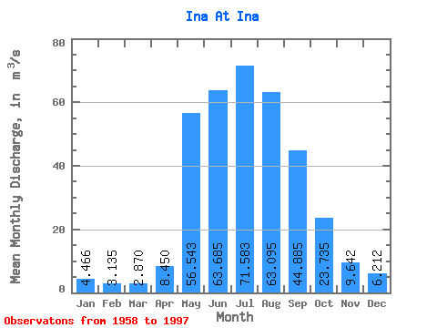
| Statistic | Jan | Feb | Mar | Apr | May | Jun | Jul | Aug | Sep | Oct | Nov | Dec | Annual |
|---|---|---|---|---|---|---|---|---|---|---|---|---|---|
| Mean | 4.47 | 3.13 | 2.87 | 8.45 | 56.54 | 63.69 | 71.58 | 63.09 | 44.88 | 23.73 | 9.64 | 6.21 | 29.86 |
| Standard Deviation | 2.10 | 1.76 | 1.94 | 5.56 | 20.49 | 28.83 | 43.22 | 31.44 | 20.39 | 9.14 | 4.11 | 2.67 | 8.49 |
| Min | 2.23 | 0.60 | 0.75 | 2.59 | 15.30 | 16.60 | 16.80 | 19.80 | 19.70 | 10.60 | 2.67 | 2.86 | 14.05 |
| Max | 13.20 | 9.64 | 11.90 | 29.10 | 128.00 | 149.00 | 210.00 | 146.00 | 98.30 | 48.00 | 20.40 | 17.00 | 45.35 |
| Coefficient of Variation | 0.47 | 0.56 | 0.68 | 0.66 | 0.36 | 0.45 | 0.60 | 0.50 | 0.45 | 0.39 | 0.43 | 0.43 | 0.28 |
 Return to R-Arctic Net Home Page