|
|
|||||||||||||||||
| Point ID: 6404 | Downloads | Plots | Site Data | Code: 7022 |
|
|
|||||||||||||||||
| Download | |
|---|---|
| Site Descriptor Information | Site Time Series Data |
| Link to all available data | |
| View: | Time Series | All |
| Units: | mm |
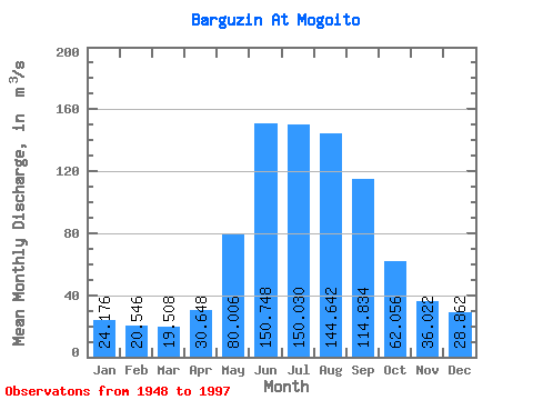
| Statistic | Jan | Feb | Mar | Apr | May | Jun | Jul | Aug | Sep | Oct | Nov | Dec | Annual |
|---|---|---|---|---|---|---|---|---|---|---|---|---|---|
| Mean | 24.18 | 20.55 | 19.51 | 30.65 | 80.01 | 150.75 | 150.03 | 144.64 | 114.83 | 62.06 | 36.02 | 28.86 | 71.84 |
| Standard Deviation | 6.96 | 5.97 | 5.61 | 14.01 | 33.44 | 56.18 | 65.33 | 69.26 | 44.35 | 16.28 | 11.04 | 8.04 | 16.96 |
| Min | 14.30 | 9.60 | 8.41 | 0.22 | 28.00 | 72.40 | 48.10 | 51.20 | 55.60 | 37.00 | 21.60 | 17.10 | 45.48 |
| Max | 41.10 | 36.40 | 36.30 | 107.00 | 227.00 | 357.00 | 304.00 | 425.00 | 260.00 | 127.00 | 79.60 | 55.20 | 122.06 |
| Coefficient of Variation | 0.29 | 0.29 | 0.29 | 0.46 | 0.42 | 0.37 | 0.43 | 0.48 | 0.39 | 0.26 | 0.31 | 0.28 | 0.24 |
 Return to R-Arctic Net Home Page