|
|
|||||||||||||||||
| Point ID: 6353 | Downloads | Plots | Site Data | Code: 3871 |
|
|
|||||||||||||||||
| Download | |
|---|---|
| Site Descriptor Information | Site Time Series Data |
| Link to all available data | |
| View: | Time Series | All |
| Units: | mm |
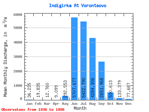
| Statistic | Jan | Feb | Mar | Apr | May | Jun | Jul | Aug | Sep | Oct | Nov | Dec | Annual |
|---|---|---|---|---|---|---|---|---|---|---|---|---|---|
| Mean | 36.23 | 19.84 | 12.76 | 9.10 | 292.55 | 5707.68 | 5422.79 | 4284.31 | 2651.97 | 530.61 | 133.38 | 77.69 | 1590.16 |
| Standard Deviation | 10.49 | 7.44 | 6.03 | 4.96 | 424.96 | 1638.20 | 1449.43 | 1467.44 | 1055.35 | 215.28 | 34.75 | 21.25 | 323.94 |
| Min | 18.60 | 11.60 | 3.84 | 3.28 | 6.00 | 1990.00 | 2525.00 | 2090.00 | 1170.00 | 215.00 | 82.10 | 44.10 | 1003.67 |
| Max | 72.00 | 62.00 | 48.00 | 34.00 | 1980.00 | 10600.00 | 8580.00 | 9646.00 | 5902.00 | 1434.00 | 245.00 | 144.00 | 2527.10 |
| Coefficient of Variation | 0.29 | 0.38 | 0.47 | 0.55 | 1.45 | 0.29 | 0.27 | 0.34 | 0.40 | 0.41 | 0.26 | 0.27 | 0.20 |
 Return to R-Arctic Net Home Page