|
|
|||||||||||||||||
| Point ID: 6325 | Downloads | Plots | Site Data | Other Close Sites | Code: 3574 |
|
|
|||||||||||||||||
| Download | |
|---|---|
| Site Descriptor Information | Site Time Series Data |
| Link to all available data | |
| View: | Time Series | All |
| Units: | mm |
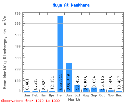
| Statistic | Jan | Feb | Mar | Apr | May | Jun | Jul | Aug | Sep | Oct | Nov | Dec | Annual |
|---|---|---|---|---|---|---|---|---|---|---|---|---|---|
| Mean | 8.48 | 8.52 | 8.63 | 12.15 | 665.31 | 256.82 | 59.44 | 33.53 | 39.09 | 25.62 | 14.46 | 10.47 | 98.98 |
| Standard Deviation | 2.82 | 3.10 | 3.65 | 6.61 | 250.66 | 162.00 | 49.96 | 22.85 | 32.76 | 17.47 | 6.60 | 3.18 | 25.32 |
| Min | 4.88 | 3.47 | 3.08 | 4.37 | 0.67 | 3.61 | 4.77 | 1.34 | 0.12 | 0.03 | 9.28 | 5.05 | 66.05 |
| Max | 13.50 | 15.10 | 16.60 | 30.80 | 1050.00 | 539.00 | 185.00 | 78.40 | 113.00 | 66.90 | 31.60 | 15.40 | 147.95 |
| Coefficient of Variation | 0.33 | 0.36 | 0.42 | 0.54 | 0.38 | 0.63 | 0.84 | 0.68 | 0.84 | 0.68 | 0.46 | 0.30 | 0.26 |
| Other Close Sites | ||||||
|---|---|---|---|---|---|---|
| PointID | Latitude | Longitude | Drainage Area | Source | Name | |
| 6208 | "Nuya At Komaka" | 60.27 | 1367554 | SHI | 554.00 | |
| 6209 | "Nuya At Kurum" | 60.27 | 1367554 | SHI | 132.00 | |
 Return to R-Arctic Net Home Page