|
|
|||||||||||||||||
| Point ID: 6324 | Downloads | Plots | Site Data | Code: 3569 |
|
|
|||||||||||||||||
| Download | |
|---|---|
| Site Descriptor Information | Site Time Series Data |
| Link to all available data | |
| View: | Time Series | All |
| Units: | mm |
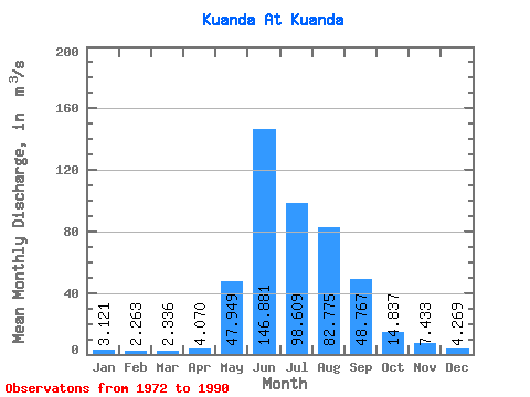
| Statistic | Jan | Feb | Mar | Apr | May | Jun | Jul | Aug | Sep | Oct | Nov | Dec | Annual |
|---|---|---|---|---|---|---|---|---|---|---|---|---|---|
| Mean | 3.12 | 2.26 | 2.34 | 4.07 | 47.95 | 146.88 | 98.61 | 82.78 | 48.77 | 14.84 | 7.43 | 4.27 | 41.20 |
| Standard Deviation | 1.19 | 1.10 | 1.25 | 1.76 | 31.58 | 58.79 | 68.29 | 60.23 | 28.75 | 5.23 | 2.18 | 0.98 | 12.69 |
| Min | 0.05 | 0.00 | 0.00 | 0.10 | 1.03 | 1.71 | 1.14 | 1.03 | 0.41 | 0.06 | 4.26 | 2.89 | 21.61 |
| Max | 4.81 | 4.14 | 4.57 | 6.22 | 121.00 | 230.00 | 225.00 | 240.00 | 107.00 | 21.70 | 13.30 | 5.86 | 68.84 |
| Coefficient of Variation | 0.38 | 0.49 | 0.54 | 0.43 | 0.66 | 0.40 | 0.69 | 0.73 | 0.59 | 0.35 | 0.29 | 0.23 | 0.31 |
 Return to R-Arctic Net Home Page