|
|
|||||||||||||||||
| Point ID: 6317 | Downloads | Plots | Site Data | Code: 3559 |
|
|
|||||||||||||||||
| Download | |
|---|---|
| Site Descriptor Information | Site Time Series Data |
| Link to all available data | |
| View: | Time Series | All |
| Units: | mm |
| Statistic | Jan | Feb | Mar | Apr | May | Jun | Jul | Aug | Sep | Oct | Nov | Dec | Annual |
|---|---|---|---|---|---|---|---|---|---|---|---|---|---|
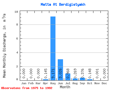
| Mean | 0.00 | 0.00 | 0.00 | 0.14 | 9.17 | 3.03 | 0.97 | 0.27 | 0.38 | 0.15 | 0.00 | 0.00 | 1.19 |
| Standard Deviation | 0.00 | 0.00 | 0.00 | 0.32 | 7.29 | 2.73 | 2.43 | 0.67 | 0.81 | 0.40 | 0.00 | 0.00 | 0.77 |
| Min | 0.00 | 0.00 | 0.00 | 0.00 | 0.28 | 0.23 | 0.01 | 0.00 | 0.00 | 0.00 | 0.00 | 0.00 | 0.09 |
| Max | 0.00 | 0.00 | 0.00 | 1.03 | 25.60 | 8.52 | 9.69 | 2.65 | 2.60 | 1.51 | 0.01 | 0.00 | 2.37 |
| Coefficient of Variation | 2.21 | 0.80 | 0.90 | 2.52 | 2.48 | 2.17 | 2.74 | 3.61 | 0.65 |
 Return to R-Arctic Net Home Page