|
|
|||||||||||||||||
| Point ID: 6304 | Downloads | Plots | Site Data | Code: 3489 |
|
|
|||||||||||||||||
| Download | |
|---|---|
| Site Descriptor Information | Site Time Series Data |
| Link to all available data | |
| View: | Time Series | All |
| Units: | mm |
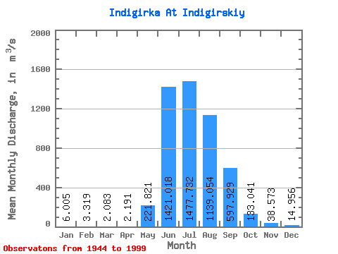
| Statistic | Jan | Feb | Mar | Apr | May | Jun | Jul | Aug | Sep | Oct | Nov | Dec | Annual |
|---|---|---|---|---|---|---|---|---|---|---|---|---|---|
| Mean | 6.00 | 3.32 | 2.08 | 2.19 | 221.82 | 1421.02 | 1477.73 | 1139.05 | 597.93 | 133.04 | 38.57 | 14.96 | 421.48 |
| Standard Deviation | 2.19 | 1.45 | 1.37 | 1.87 | 233.74 | 556.26 | 468.09 | 395.42 | 274.92 | 92.69 | 9.71 | 4.81 | 92.05 |
| Min | 2.23 | 0.84 | 0.20 | -0.85 | 12.80 | 413.00 | 749.00 | 532.00 | 272.00 | 64.20 | 20.10 | 6.63 | 238.33 |
| Max | 11.30 | 7.07 | 5.48 | 9.96 | 1240.00 | 3100.00 | 2670.00 | 2040.00 | 1500.00 | 765.00 | 65.70 | 26.10 | 685.18 |
| Coefficient of Variation | 0.36 | 0.44 | 0.66 | 0.86 | 1.05 | 0.39 | 0.32 | 0.35 | 0.46 | 0.70 | 0.25 | 0.32 | 0.22 |
 Return to R-Arctic Net Home Page