|
|
|||||||||||||||||
| Point ID: 6302 | Downloads | Plots | Site Data | Code: 3483 |
|
|
|||||||||||||||||
| Download | |
|---|---|
| Site Descriptor Information | Site Time Series Data |
| Link to all available data | |
| View: | Time Series | All |
| Units: | mm |
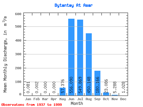
| Statistic | Jan | Feb | Mar | Apr | May | Jun | Jul | Aug | Sep | Oct | Nov | Dec | Annual |
|---|---|---|---|---|---|---|---|---|---|---|---|---|---|
| Mean | 0.08 | 0.00 | 0.00 | 0.00 | 57.38 | 556.09 | 549.87 | 450.15 | 180.17 | 23.09 | 5.29 | 1.03 | 152.96 |
| Standard Deviation | 0.21 | 0.02 | 0.00 | 0.00 | 59.64 | 276.87 | 249.41 | 215.20 | 96.37 | 9.80 | 2.38 | 0.91 | 50.56 |
| Min | 0.00 | 0.00 | 0.00 | 0.00 | 0.00 | 99.50 | 145.00 | 135.00 | 69.60 | 7.60 | 1.48 | 0.10 | 52.89 |
| Max | 1.22 | 0.12 | 0.00 | 0.00 | 255.00 | 1420.00 | 1150.00 | 981.00 | 469.00 | 54.00 | 15.40 | 4.75 | 318.23 |
| Coefficient of Variation | 2.56 | 6.69 | 1.04 | 0.50 | 0.45 | 0.48 | 0.54 | 0.42 | 0.45 | 0.89 | 0.33 |
 Return to R-Arctic Net Home Page