|
|
|||||||||||||||||
| Point ID: 6298 | Downloads | Plots | Site Data | Code: 3445 |
|
|
|||||||||||||||||
| Download | |
|---|---|
| Site Descriptor Information | Site Time Series Data |
| Link to all available data | |
| View: | Time Series | All |
| Units: | mm |
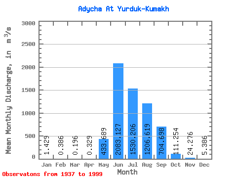
| Statistic | Jan | Feb | Mar | Apr | May | Jun | Jul | Aug | Sep | Oct | Nov | Dec | Annual |
|---|---|---|---|---|---|---|---|---|---|---|---|---|---|
| Mean | 1.43 | 0.39 | 0.20 | 0.33 | 433.69 | 2083.13 | 1530.21 | 1206.62 | 704.70 | 111.25 | 24.28 | 5.39 | 512.50 |
| Standard Deviation | 1.06 | 0.54 | 0.40 | 0.59 | 350.05 | 849.00 | 519.87 | 543.08 | 387.30 | 54.33 | 9.57 | 3.00 | 126.96 |
| Min | 0.00 | 0.00 | 0.00 | 0.00 | 4.05 | 744.00 | 519.00 | 255.00 | 202.00 | 40.00 | 10.40 | 0.62 | 263.52 |
| Max | 3.70 | 2.32 | 1.72 | 2.07 | 2210.00 | 5570.00 | 3210.00 | 2820.00 | 2290.00 | 326.00 | 53.70 | 16.70 | 1023.56 |
| Coefficient of Variation | 0.74 | 1.39 | 2.04 | 1.80 | 0.81 | 0.41 | 0.34 | 0.45 | 0.55 | 0.49 | 0.39 | 0.56 | 0.25 |
 Return to R-Arctic Net Home Page