|
|
|||||||||||||||||
| Point ID: 6292 | Downloads | Plots | Site Data | Code: 3407 |
|
|
|||||||||||||||||
| Download | |
|---|---|
| Site Descriptor Information | Site Time Series Data |
| Link to all available data | |
| View: | Time Series | All |
| Units: | mm |
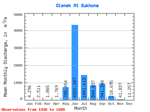
| Statistic | Jan | Feb | Mar | Apr | May | Jun | Jul | Aug | Sep | Oct | Nov | Dec | Annual |
|---|---|---|---|---|---|---|---|---|---|---|---|---|---|
| Mean | 4.30 | 2.51 | 1.86 | 1.77 | 745.45 | 4320.39 | 1441.61 | 844.84 | 941.35 | 218.69 | 41.84 | 11.26 | 714.82 |
| Standard Deviation | 2.19 | 1.68 | 1.52 | 1.45 | 949.76 | 1264.11 | 929.40 | 619.70 | 543.76 | 149.74 | 28.57 | 6.22 | 179.55 |
| Min | 0.77 | 0.22 | 0.17 | 0.16 | 0.99 | 1750.00 | 133.00 | 77.90 | 93.80 | 23.20 | 6.74 | 3.00 | 296.13 |
| Max | 11.50 | 9.32 | 8.14 | 8.17 | 3670.00 | 7190.00 | 5140.00 | 2670.00 | 2570.00 | 740.00 | 218.00 | 31.60 | 1251.88 |
| Coefficient of Variation | 0.51 | 0.67 | 0.82 | 0.82 | 1.27 | 0.29 | 0.65 | 0.73 | 0.58 | 0.69 | 0.68 | 0.55 | 0.25 |
 Return to R-Arctic Net Home Page