|
|
|||||||||||||||||
| Point ID: 6288 | Downloads | Plots | Site Data | Code: 3397 |
|
|
|||||||||||||||||
| Download | |
|---|---|
| Site Descriptor Information | Site Time Series Data |
| Link to all available data | |
| View: | Time Series | All |
| Units: | mm |
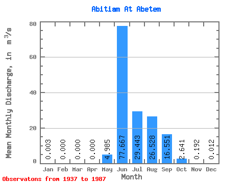
| Statistic | Jan | Feb | Mar | Apr | May | Jun | Jul | Aug | Sep | Oct | Nov | Dec | Annual |
|---|---|---|---|---|---|---|---|---|---|---|---|---|---|
| Mean | 0.00 | 0.00 | 0.00 | 0.00 | 4.99 | 77.67 | 29.44 | 26.53 | 16.55 | 2.64 | 0.19 | 0.01 | 13.21 |
| Standard Deviation | 0.01 | 0.00 | 0.00 | 0.00 | 7.13 | 28.11 | 16.05 | 13.53 | 11.21 | 3.99 | 0.43 | 0.03 | 3.43 |
| Min | 0.00 | 0.00 | 0.00 | 0.00 | 0.00 | 27.60 | 7.25 | 6.31 | 1.62 | 0.03 | 0.00 | 0.00 | 6.16 |
| Max | 0.05 | 0.01 | 0.00 | 0.00 | 32.80 | 146.00 | 76.70 | 61.20 | 47.90 | 19.10 | 2.92 | 0.13 | 19.55 |
| Coefficient of Variation | 4.23 | 6.00 | 7.00 | 1.43 | 0.36 | 0.55 | 0.51 | 0.68 | 1.51 | 2.24 | 2.64 | 0.26 |
 Return to R-Arctic Net Home Page