|
|
|||||||||||||||||
| Point ID: 6287 | Downloads | Plots | Site Data | Code: 3394 |
|
|
|||||||||||||||||
| Download | |
|---|---|
| Site Descriptor Information | Site Time Series Data |
| Link to all available data | |
| View: | Time Series | All |
| Units: | mm |
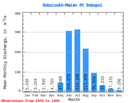
| Statistic | Jan | Feb | Mar | Apr | May | Jun | Jul | Aug | Sep | Oct | Nov | Dec | Annual |
|---|---|---|---|---|---|---|---|---|---|---|---|---|---|
| Mean | 5.03 | 3.20 | 2.94 | 4.72 | 47.09 | 305.88 | 313.19 | 217.49 | 95.51 | 34.23 | 17.13 | 9.16 | 82.38 |
| Standard Deviation | 5.09 | 3.38 | 3.84 | 3.96 | 39.15 | 118.71 | 112.17 | 109.16 | 47.68 | 14.80 | 12.72 | 9.10 | 21.25 |
| Min | 1.23 | 0.96 | 0.50 | 1.68 | 11.10 | 94.00 | 156.00 | 89.70 | 39.20 | 7.42 | 1.55 | 1.25 | 54.54 |
| Max | 21.10 | 13.80 | 15.10 | 17.00 | 141.00 | 473.00 | 576.00 | 409.00 | 185.00 | 72.80 | 57.00 | 37.10 | 121.04 |
| Coefficient of Variation | 1.01 | 1.06 | 1.31 | 0.84 | 0.83 | 0.39 | 0.36 | 0.50 | 0.50 | 0.43 | 0.74 | 0.99 | 0.26 |
 Return to R-Arctic Net Home Page