|
|
|||||||||||||||||
| Point ID: 6280 | Downloads | Plots | Site Data | Code: 3367 |
|
|
|||||||||||||||||
| Download | |
|---|---|
| Site Descriptor Information | Site Time Series Data |
| Link to all available data | |
| View: | Time Series | All |
| Units: | mm |
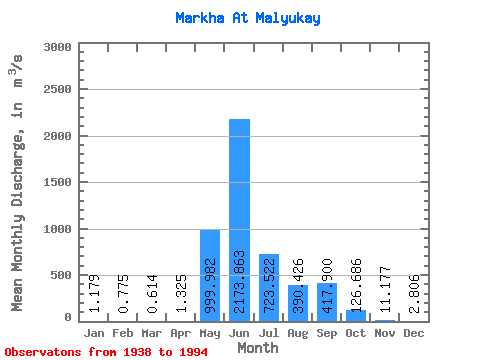
| Statistic | Jan | Feb | Mar | Apr | May | Jun | Jul | Aug | Sep | Oct | Nov | Dec | Annual |
|---|---|---|---|---|---|---|---|---|---|---|---|---|---|
| Mean | 1.18 | 0.78 | 0.61 | 1.32 | 999.98 | 2173.86 | 723.52 | 390.43 | 417.90 | 126.69 | 11.18 | 2.81 | 405.48 |
| Standard Deviation | 1.03 | 0.96 | 0.78 | 5.34 | 722.91 | 778.79 | 569.36 | 434.36 | 302.78 | 85.08 | 6.04 | 1.83 | 120.90 |
| Min | 0.00 | 0.00 | 0.00 | 0.00 | 4.31 | 711.00 | 88.10 | 13.30 | 26.20 | 14.50 | 0.66 | 0.03 | 193.67 |
| Max | 3.18 | 3.29 | 2.65 | 37.40 | 3400.00 | 3930.00 | 2610.00 | 2390.00 | 1180.00 | 362.00 | 25.60 | 9.13 | 717.61 |
| Coefficient of Variation | 0.87 | 1.24 | 1.27 | 4.03 | 0.72 | 0.36 | 0.79 | 1.11 | 0.72 | 0.67 | 0.54 | 0.65 | 0.30 |
 Return to R-Arctic Net Home Page