|
|
|||||||||||||||||
| Point ID: 6269 | Downloads | Plots | Site Data | Other Close Sites | Code: 3335 |
|
|
|||||||||||||||||
| Download | |
|---|---|
| Site Descriptor Information | Site Time Series Data |
| Link to all available data | |
| View: | Time Series | All |
| Units: | mm |
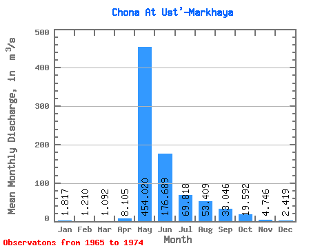
| Statistic | Jan | Feb | Mar | Apr | May | Jun | Jul | Aug | Sep | Oct | Nov | Dec | Annual |
|---|---|---|---|---|---|---|---|---|---|---|---|---|---|
| Mean | 1.82 | 1.21 | 1.09 | 8.11 | 454.02 | 176.69 | 69.82 | 53.41 | 33.05 | 19.59 | 4.75 | 2.42 | 69.51 |
| Standard Deviation | 1.10 | 0.86 | 0.57 | 16.59 | 205.74 | 83.82 | 75.82 | 92.34 | 24.59 | 12.32 | 2.91 | 1.13 | 25.56 |
| Min | 0.44 | 0.00 | 0.22 | 0.03 | 35.20 | 79.50 | 6.16 | 6.68 | 9.41 | 6.93 | 2.35 | 1.09 | 44.04 |
| Max | 4.01 | 3.18 | 1.90 | 52.50 | 752.00 | 347.00 | 254.00 | 286.00 | 79.10 | 47.40 | 11.60 | 4.12 | 126.85 |
| Coefficient of Variation | 0.60 | 0.71 | 0.52 | 2.05 | 0.45 | 0.47 | 1.09 | 1.73 | 0.74 | 0.63 | 0.61 | 0.47 | 0.37 |
| Other Close Sites | ||||||
|---|---|---|---|---|---|---|
| PointID | Latitude | Longitude | Drainage Area | Source | Name | |
| 6268 | "Chona At Chona" | 61.90 | 1036691 | SHI | 296.00 | |
 Return to R-Arctic Net Home Page