|
|
|||||||||||||||||
| Point ID: 6267 | Downloads | Plots | Site Data | Code: 3332 |
|
|
|||||||||||||||||
| Download | |
|---|---|
| Site Descriptor Information | Site Time Series Data |
| Link to all available data | |
| View: | Time Series | All |
| Units: | mm |
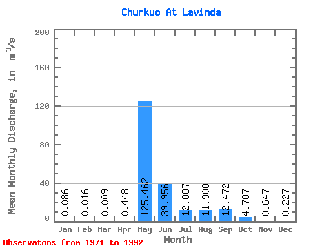
| Statistic | Jan | Feb | Mar | Apr | May | Jun | Jul | Aug | Sep | Oct | Nov | Dec | Annual |
|---|---|---|---|---|---|---|---|---|---|---|---|---|---|
| Mean | 0.09 | 0.02 | 0.01 | 0.45 | 125.46 | 39.96 | 12.09 | 11.90 | 12.47 | 4.79 | 0.65 | 0.23 | 21.75 |
| Standard Deviation | 0.09 | 0.02 | 0.01 | 0.61 | 41.84 | 26.03 | 17.67 | 15.08 | 13.84 | 4.45 | 0.77 | 0.20 | 0.35 |
| Min | 0.00 | 0.00 | 0.00 | 0.00 | 61.80 | 3.96 | 1.13 | 0.24 | 0.21 | 0.22 | 0.12 | 0.01 | 21.50 |
| Max | 0.32 | 0.07 | 0.02 | 1.48 | 216.00 | 83.20 | 59.50 | 53.20 | 46.70 | 13.70 | 3.25 | 0.69 | 22.00 |
| Coefficient of Variation | 1.03 | 1.38 | 1.10 | 1.37 | 0.33 | 0.65 | 1.46 | 1.27 | 1.11 | 0.93 | 1.19 | 0.89 | 0.02 |
 Return to R-Arctic Net Home Page