|
|
|||||||||||||||||
| Point ID: 6266 | Downloads | Plots | Site Data | Code: 3329 |
|
|
|||||||||||||||||
| Download | |
|---|---|
| Site Descriptor Information | Site Time Series Data |
| Link to all available data | |
| View: | Time Series | All |
| Units: | mm |
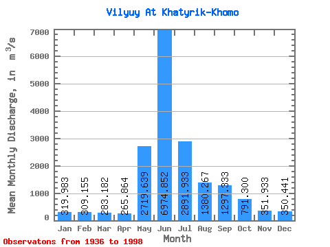
| Statistic | Jan | Feb | Mar | Apr | May | Jun | Jul | Aug | Sep | Oct | Nov | Dec | Annual |
|---|---|---|---|---|---|---|---|---|---|---|---|---|---|
| Mean | 319.98 | 309.15 | 283.18 | 265.86 | 2719.64 | 6974.85 | 2891.93 | 1380.27 | 1297.33 | 791.30 | 351.93 | 350.44 | 1480.40 |
| Standard Deviation | 368.79 | 368.89 | 336.08 | 308.00 | 1619.38 | 2711.62 | 1362.69 | 1052.31 | 1001.80 | 504.42 | 233.75 | 348.71 | 418.51 |
| Min | 10.00 | 12.00 | 9.00 | 11.80 | 280.00 | 2610.00 | 768.00 | 207.00 | 180.00 | 103.00 | 77.00 | 21.70 | 745.24 |
| Max | 1020.00 | 1020.00 | 899.00 | 921.00 | 7740.00 | 15100.00 | 6260.00 | 5650.00 | 4220.00 | 2320.00 | 830.00 | 983.00 | 2750.58 |
| Coefficient of Variation | 1.15 | 1.19 | 1.19 | 1.16 | 0.59 | 0.39 | 0.47 | 0.76 | 0.77 | 0.64 | 0.66 | 0.99 | 0.28 |
 Return to R-Arctic Net Home Page