|
|
|||||||||||||||||
| Point ID: 6265 | Downloads | Plots | Site Data | Code: 3321 |
|
|
|||||||||||||||||
| Download | |
|---|---|
| Site Descriptor Information | Site Time Series Data |
| Link to all available data | |
| View: | Time Series | All |
| Units: | mm |
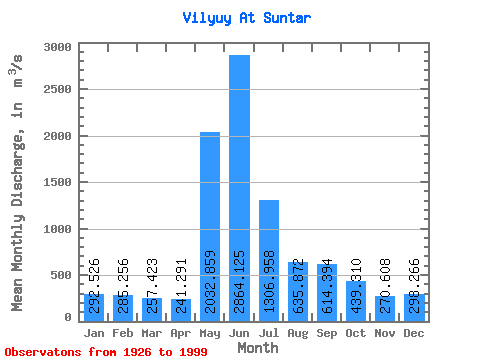
| Statistic | Jan | Feb | Mar | Apr | May | Jun | Jul | Aug | Sep | Oct | Nov | Dec | Annual |
|---|---|---|---|---|---|---|---|---|---|---|---|---|---|
| Mean | 292.53 | 285.26 | 257.42 | 241.29 | 2032.86 | 2864.12 | 1306.96 | 635.87 | 614.39 | 439.31 | 270.61 | 298.27 | 787.53 |
| Standard Deviation | 377.11 | 367.87 | 332.88 | 327.44 | 1025.96 | 1807.32 | 693.31 | 520.50 | 432.39 | 282.80 | 256.38 | 355.47 | 225.02 |
| Min | 2.08 | 1.20 | 0.92 | 0.60 | 287.00 | 630.00 | 261.00 | 13.80 | 93.40 | 39.90 | 13.20 | 5.59 | 384.58 |
| Max | 997.00 | 964.00 | 915.00 | 1340.00 | 4360.00 | 8330.00 | 3630.00 | 2740.00 | 1910.00 | 1680.00 | 801.00 | 943.00 | 1474.08 |
| Coefficient of Variation | 1.29 | 1.29 | 1.29 | 1.36 | 0.51 | 0.63 | 0.53 | 0.82 | 0.70 | 0.64 | 0.95 | 1.19 | 0.29 |
 Return to R-Arctic Net Home Page