|
|
|||||||||||||||||
| Point ID: 6264 | Downloads | Plots | Site Data | Code: 3315 |
|
|
|||||||||||||||||
| Download | |
|---|---|
| Site Descriptor Information | Site Time Series Data |
| Link to all available data | |
| View: | Time Series | All |
| Units: | mm |
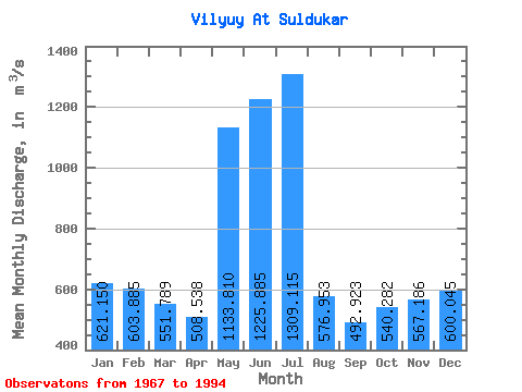
| Statistic | Jan | Feb | Mar | Apr | May | Jun | Jul | Aug | Sep | Oct | Nov | Dec | Annual |
|---|---|---|---|---|---|---|---|---|---|---|---|---|---|
| Mean | 621.15 | 603.88 | 551.79 | 508.54 | 1133.81 | 1225.88 | 1309.12 | 576.95 | 492.92 | 540.28 | 567.19 | 600.04 | 706.08 |
| Standard Deviation | 276.03 | 256.51 | 235.62 | 294.39 | 472.80 | 654.30 | 698.67 | 606.67 | 405.54 | 282.53 | 256.55 | 242.40 | 213.32 |
| Min | 1.15 | 0.28 | 0.26 | 33.60 | 553.00 | 554.00 | 198.00 | 8.78 | 97.00 | 62.20 | 39.20 | 28.60 | 330.51 |
| Max | 948.00 | 933.00 | 833.00 | 1490.00 | 2430.00 | 2630.00 | 2700.00 | 2530.00 | 1900.00 | 1490.00 | 1120.00 | 887.00 | 1306.67 |
| Coefficient of Variation | 0.44 | 0.42 | 0.43 | 0.58 | 0.42 | 0.53 | 0.53 | 1.05 | 0.82 | 0.52 | 0.45 | 0.40 | 0.30 |
 Return to R-Arctic Net Home Page