|
|
|||||||||||||||||
| Point ID: 6252 | Downloads | Plots | Site Data | Code: 3281 |
|
|
|||||||||||||||||
| Download | |
|---|---|
| Site Descriptor Information | Site Time Series Data |
| Link to all available data | |
| View: | Time Series | All |
| Units: | mm |
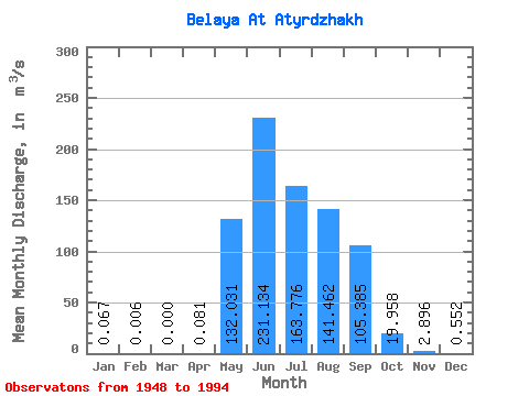
| Statistic | Jan | Feb | Mar | Apr | May | Jun | Jul | Aug | Sep | Oct | Nov | Dec | Annual |
|---|---|---|---|---|---|---|---|---|---|---|---|---|---|
| Mean | 0.07 | 0.01 | 0.00 | 0.08 | 132.03 | 231.13 | 163.78 | 141.46 | 105.39 | 19.96 | 2.90 | 0.55 | 66.51 |
| Standard Deviation | 0.09 | 0.02 | 0.00 | 0.29 | 62.83 | 124.89 | 74.67 | 70.58 | 67.48 | 11.86 | 2.26 | 0.55 | 21.29 |
| Min | 0.00 | 0.00 | 0.00 | 0.00 | 22.60 | 57.80 | 52.70 | 42.90 | 20.00 | 3.05 | 0.13 | 0.00 | 27.96 |
| Max | 0.40 | 0.07 | 0.00 | 1.66 | 257.00 | 523.00 | 356.00 | 330.00 | 292.00 | 49.80 | 10.30 | 3.12 | 112.20 |
| Coefficient of Variation | 1.27 | 2.85 | 3.65 | 0.48 | 0.54 | 0.46 | 0.50 | 0.64 | 0.59 | 0.78 | 0.99 | 0.32 |
 Return to R-Arctic Net Home Page