|
|
|||||||||||||||||
| Point ID: 6249 | Downloads | Plots | Site Data | Code: 3275 |
|
|
|||||||||||||||||
| Download | |
|---|---|
| Site Descriptor Information | Site Time Series Data |
| Link to all available data | |
| View: | Time Series | All |
| Units: | mm |
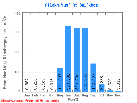
| Statistic | Jan | Feb | Mar | Apr | May | Jun | Jul | Aug | Sep | Oct | Nov | Dec | Annual |
|---|---|---|---|---|---|---|---|---|---|---|---|---|---|
| Mean | 0.89 | 0.22 | 0.11 | 0.32 | 121.81 | 330.31 | 320.00 | 321.05 | 142.41 | 37.34 | 8.54 | 3.31 | 99.86 |
| Standard Deviation | 1.78 | 0.48 | 0.34 | 0.84 | 67.88 | 221.77 | 126.18 | 201.44 | 64.80 | 41.88 | 8.42 | 4.81 | 31.61 |
| Min | 0.00 | 0.00 | 0.00 | 0.00 | 51.70 | 28.00 | 156.00 | 98.80 | 36.10 | 0.71 | 0.03 | 0.00 | 65.14 |
| Max | 6.44 | 1.48 | 1.08 | 2.94 | 281.00 | 873.00 | 579.00 | 726.00 | 273.00 | 149.00 | 26.50 | 15.90 | 139.73 |
| Coefficient of Variation | 2.01 | 2.17 | 3.13 | 2.65 | 0.56 | 0.67 | 0.39 | 0.63 | 0.46 | 1.12 | 0.99 | 1.45 | 0.32 |
 Return to R-Arctic Net Home Page