|
|
|||||||||||||||||
| Point ID: 6247 | Downloads | Plots | Site Data | Code: 3271 |
|
|
|||||||||||||||||
| Download | |
|---|---|
| Site Descriptor Information | Site Time Series Data |
| Link to all available data | |
| View: | Time Series | All |
| Units: | mm |
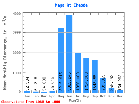
| Statistic | Jan | Feb | Mar | Apr | May | Jun | Jul | Aug | Sep | Oct | Nov | Dec | Annual |
|---|---|---|---|---|---|---|---|---|---|---|---|---|---|
| Mean | 92.53 | 64.85 | 54.01 | 76.05 | 3219.61 | 3882.25 | 1996.00 | 1734.91 | 1643.55 | 739.97 | 255.49 | 154.28 | 1159.46 |
| Standard Deviation | 26.66 | 18.66 | 16.86 | 74.51 | 1206.21 | 1635.13 | 840.80 | 840.52 | 730.70 | 338.45 | 77.99 | 43.71 | 277.50 |
| Min | 35.80 | 30.90 | 24.20 | 25.30 | 714.00 | 1170.00 | 784.00 | 538.00 | 659.00 | 316.00 | 128.00 | 80.80 | 566.65 |
| Max | 142.00 | 118.00 | 118.00 | 601.00 | 6210.00 | 8900.00 | 4520.00 | 4460.00 | 3690.00 | 1610.00 | 469.00 | 263.00 | 1945.72 |
| Coefficient of Variation | 0.29 | 0.29 | 0.31 | 0.98 | 0.38 | 0.42 | 0.42 | 0.48 | 0.45 | 0.46 | 0.30 | 0.28 | 0.24 |
 Return to R-Arctic Net Home Page