|
|
|||||||||||||||||
| Point ID: 6245 | Downloads | Plots | Site Data | Code: 3264 |
|
|
|||||||||||||||||
| Download | |
|---|---|
| Site Descriptor Information | Site Time Series Data |
| Link to all available data | |
| View: | Time Series | All |
| Units: | mm |
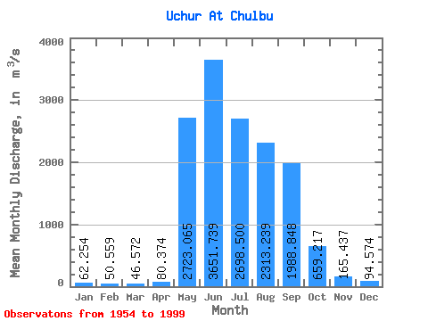
| Statistic | Jan | Feb | Mar | Apr | May | Jun | Jul | Aug | Sep | Oct | Nov | Dec | Annual |
|---|---|---|---|---|---|---|---|---|---|---|---|---|---|
| Mean | 62.25 | 50.56 | 46.57 | 80.37 | 2723.07 | 3651.74 | 2698.50 | 2313.24 | 1988.85 | 659.22 | 165.44 | 94.57 | 1211.20 |
| Standard Deviation | 20.27 | 16.29 | 14.53 | 60.59 | 1000.35 | 1375.51 | 1227.18 | 1024.00 | 744.62 | 659.08 | 56.04 | 26.08 | 236.07 |
| Min | 13.40 | 22.00 | 19.80 | 19.00 | 528.00 | 1120.00 | 822.00 | 503.00 | 758.00 | 275.00 | 75.30 | 54.70 | 782.48 |
| Max | 140.00 | 108.00 | 97.00 | 334.00 | 5080.00 | 8820.00 | 5410.00 | 5340.00 | 3640.00 | 4821.00 | 339.00 | 204.00 | 1754.46 |
| Coefficient of Variation | 0.33 | 0.32 | 0.31 | 0.75 | 0.37 | 0.38 | 0.46 | 0.44 | 0.37 | 1.00 | 0.34 | 0.28 | 0.20 |
 Return to R-Arctic Net Home Page