|
|
|||||||||||||||||
| Point ID: 6228 | Downloads | Plots | Site Data | Code: 3210 |
|
|
|||||||||||||||||
| Download | |
|---|---|
| Site Descriptor Information | Site Time Series Data |
| Link to all available data | |
| View: | Time Series | All |
| Units: | mm |
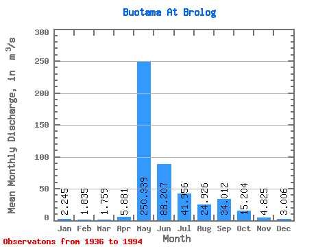
| Statistic | Jan | Feb | Mar | Apr | May | Jun | Jul | Aug | Sep | Oct | Nov | Dec | Annual |
|---|---|---|---|---|---|---|---|---|---|---|---|---|---|
| Mean | 2.25 | 1.83 | 1.76 | 5.88 | 250.34 | 88.21 | 41.96 | 24.93 | 34.01 | 15.20 | 4.83 | 3.01 | 39.70 |
| Standard Deviation | 1.12 | 0.84 | 0.75 | 14.28 | 92.36 | 58.68 | 38.35 | 19.88 | 41.93 | 13.96 | 3.06 | 1.62 | 13.02 |
| Min | 0.22 | 0.55 | 0.43 | 0.70 | 72.80 | 17.00 | 4.77 | 3.21 | 2.76 | 1.74 | 0.69 | 0.43 | 8.89 |
| Max | 5.68 | 4.17 | 4.27 | 70.10 | 455.00 | 313.00 | 215.00 | 85.80 | 237.00 | 75.30 | 17.00 | 8.89 | 74.14 |
| Coefficient of Variation | 0.50 | 0.46 | 0.43 | 2.43 | 0.37 | 0.67 | 0.91 | 0.80 | 1.23 | 0.92 | 0.64 | 0.54 | 0.33 |
 Return to R-Arctic Net Home Page