|
|
|||||||||||||||||
| Point ID: 6225 | Downloads | Plots | Site Data | Code: 3206 |
|
|
|||||||||||||||||
| Download | |
|---|---|
| Site Descriptor Information | Site Time Series Data |
| Link to all available data | |
| View: | Time Series | All |
| Units: | mm |
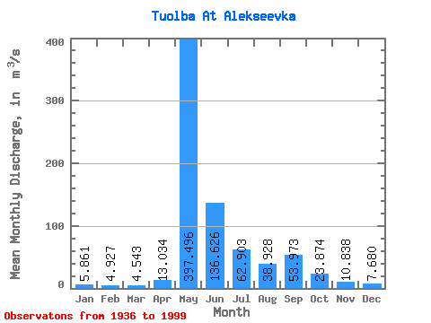
| Statistic | Jan | Feb | Mar | Apr | May | Jun | Jul | Aug | Sep | Oct | Nov | Dec | Annual |
|---|---|---|---|---|---|---|---|---|---|---|---|---|---|
| Mean | 5.86 | 4.93 | 4.54 | 13.03 | 397.50 | 136.63 | 62.90 | 38.93 | 53.97 | 23.87 | 10.84 | 7.68 | 63.22 |
| Standard Deviation | 3.49 | 2.61 | 2.44 | 24.28 | 141.08 | 82.05 | 67.68 | 43.53 | 51.83 | 17.54 | 6.60 | 4.34 | 19.42 |
| Min | 1.43 | 1.13 | 0.76 | 0.99 | 4.76 | 25.80 | 8.58 | 10.30 | 11.80 | 5.30 | 1.70 | 1.94 | 32.69 |
| Max | 21.10 | 15.30 | 13.70 | 127.00 | 735.00 | 344.00 | 325.00 | 223.00 | 242.00 | 87.30 | 36.10 | 27.20 | 124.05 |
| Coefficient of Variation | 0.59 | 0.53 | 0.54 | 1.86 | 0.35 | 0.60 | 1.08 | 1.12 | 0.96 | 0.73 | 0.61 | 0.56 | 0.31 |
 Return to R-Arctic Net Home Page