|
|
|||||||||||||||||
| Point ID: 6221 | Downloads | Plots | Site Data | Code: 3180 |
|
|
|||||||||||||||||
| Download | |
|---|---|
| Site Descriptor Information | Site Time Series Data |
| Link to all available data | |
| View: | Time Series | All |
| Units: | mm |
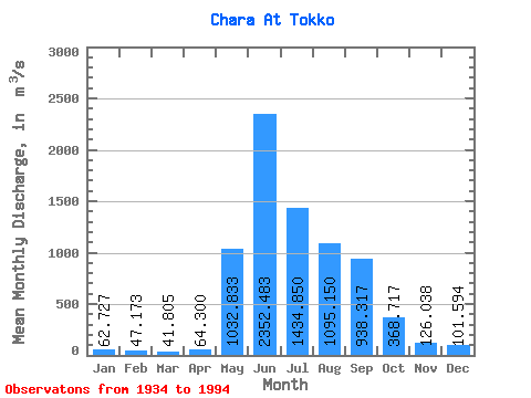
| Statistic | Jan | Feb | Mar | Apr | May | Jun | Jul | Aug | Sep | Oct | Nov | Dec | Annual |
|---|---|---|---|---|---|---|---|---|---|---|---|---|---|
| Mean | 62.73 | 47.17 | 41.80 | 64.30 | 1032.83 | 2352.48 | 1434.85 | 1095.15 | 938.32 | 368.72 | 126.04 | 101.59 | 638.83 |
| Standard Deviation | 13.24 | 9.77 | 9.19 | 33.98 | 328.72 | 569.03 | 534.51 | 530.08 | 424.59 | 112.16 | 41.00 | 100.50 | 128.82 |
| Min | 37.70 | 30.70 | 26.00 | 26.70 | 302.00 | 1440.00 | 495.00 | 324.00 | 351.00 | 156.00 | 59.80 | 7.25 | 395.37 |
| Max | 93.70 | 66.70 | 63.90 | 221.00 | 2030.00 | 3930.00 | 2750.00 | 3470.00 | 2460.00 | 757.00 | 253.00 | 843.00 | 1153.81 |
| Coefficient of Variation | 0.21 | 0.21 | 0.22 | 0.53 | 0.32 | 0.24 | 0.37 | 0.48 | 0.45 | 0.30 | 0.33 | 0.99 | 0.20 |
 Return to R-Arctic Net Home Page