|
|
|||||||||||||||||
| Point ID: 622 | Downloads | Plots | Site Data | Code: 07AF013 |
|
|
|||||||||||||||||
| Download | |
|---|---|
| Site Descriptor Information | Site Time Series Data |
| Link to all available data | |
| View: | Time Series | All |
| Units: | mm |
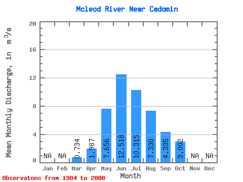
| Statistic | Jan | Feb | Mar | Apr | May | Jun | Jul | Aug | Sep | Oct | Nov | Dec | Annual |
|---|---|---|---|---|---|---|---|---|---|---|---|---|---|
| Mean | 0.73 | 1.99 | 7.66 | 12.52 | 10.31 | 7.33 | 4.33 | 3.00 | |||||
| Standard Deviation | 0.28 | 0.89 | 3.73 | 5.10 | 6.45 | 4.60 | 2.12 | 1.42 | |||||
| Min | 0.44 | 0.92 | 3.19 | 4.39 | 2.72 | 2.11 | 2.05 | 1.53 | |||||
| Max | 1.51 | 4.29 | 16.70 | 25.20 | 28.90 | 17.30 | 9.17 | 7.12 | |||||
| Coefficient of Variation | 0.38 | 0.45 | 0.49 | 0.41 | 0.62 | 0.63 | 0.49 | 0.47 |
 Return to R-Arctic Net Home Page