|
|
|||||||||||||||||
| Point ID: 6211 | Downloads | Plots | Site Data | Code: 3158 |
|
|
|||||||||||||||||
| Download | |
|---|---|
| Site Descriptor Information | Site Time Series Data |
| Link to all available data | |
| View: | Time Series | All |
| Units: | mm |
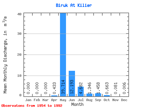
| Statistic | Jan | Feb | Mar | Apr | May | Jun | Jul | Aug | Sep | Oct | Nov | Dec | Annual |
|---|---|---|---|---|---|---|---|---|---|---|---|---|---|
| Mean | 0.00 | 0.00 | 0.00 | 0.43 | 39.71 | 12.19 | 4.68 | 1.35 | 1.46 | 0.66 | 0.08 | 0.01 | 5.25 |
| Standard Deviation | 0.00 | 0.00 | 0.00 | 1.12 | 28.68 | 8.85 | 9.51 | 2.72 | 2.23 | 0.90 | 0.10 | 0.02 | 3.50 |
| Min | 0.00 | 0.00 | 0.00 | 0.00 | 3.60 | 1.94 | 0.30 | 0.01 | 0.07 | 0.01 | 0.00 | 0.00 | 0.92 |
| Max | 0.00 | 0.00 | 0.00 | 5.23 | 113.00 | 39.80 | 56.40 | 14.30 | 8.97 | 3.91 | 0.38 | 0.11 | 16.98 |
| Coefficient of Variation | 2.58 | 0.72 | 0.73 | 2.03 | 2.02 | 1.53 | 1.35 | 1.28 | 3.31 | 0.67 |
 Return to R-Arctic Net Home Page