|
|
|||||||||||||||||
| Point ID: 6210 | Downloads | Plots | Site Data | Code: 3157 |
|
|
|||||||||||||||||
| Download | |
|---|---|
| Site Descriptor Information | Site Time Series Data |
| Link to all available data | |
| View: | Time Series | All |
| Units: | mm |
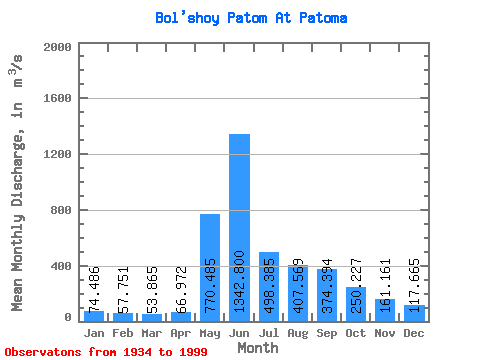
| Statistic | Jan | Feb | Mar | Apr | May | Jun | Jul | Aug | Sep | Oct | Nov | Dec | Annual |
|---|---|---|---|---|---|---|---|---|---|---|---|---|---|
| Mean | 74.49 | 57.75 | 53.87 | 66.97 | 770.49 | 1342.80 | 498.38 | 407.57 | 374.39 | 250.23 | 161.16 | 117.67 | 347.89 |
| Standard Deviation | 25.42 | 19.12 | 17.61 | 35.40 | 271.56 | 457.57 | 183.38 | 162.46 | 133.23 | 66.28 | 111.96 | 45.65 | 60.86 |
| Min | 18.60 | 14.80 | 14.40 | 18.70 | 64.50 | 537.00 | 223.00 | 193.00 | 236.00 | 109.00 | 21.10 | 13.70 | 233.68 |
| Max | 140.00 | 110.00 | 105.00 | 270.00 | 1360.00 | 2340.00 | 1030.00 | 1030.00 | 1060.00 | 435.00 | 868.00 | 298.00 | 492.62 |
| Coefficient of Variation | 0.34 | 0.33 | 0.33 | 0.53 | 0.35 | 0.34 | 0.37 | 0.40 | 0.36 | 0.27 | 0.69 | 0.39 | 0.17 |
 Return to R-Arctic Net Home Page