|
|
|||||||||||||||||
| Point ID: 6208 | Downloads | Plots | Site Data | Other Close Sites | Code: 3155 |
|
|
|||||||||||||||||
| Download | |
|---|---|
| Site Descriptor Information | Site Time Series Data |
| Link to all available data | |
| View: | Time Series | All |
| Units: | mm |
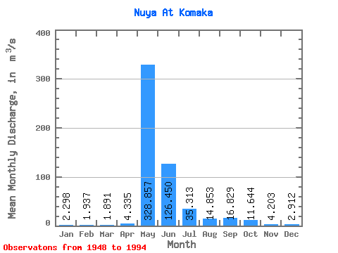
| Statistic | Jan | Feb | Mar | Apr | May | Jun | Jul | Aug | Sep | Oct | Nov | Dec | Annual |
|---|---|---|---|---|---|---|---|---|---|---|---|---|---|
| Mean | 2.30 | 1.94 | 1.89 | 4.33 | 328.86 | 126.45 | 35.31 | 14.85 | 16.83 | 11.64 | 4.20 | 2.91 | 46.24 |
| Standard Deviation | 0.82 | 0.99 | 0.96 | 5.96 | 106.97 | 83.09 | 25.47 | 12.94 | 15.68 | 9.63 | 2.15 | 1.21 | 12.11 |
| Min | 0.62 | 0.38 | 0.02 | 0.36 | 3.40 | 33.30 | 4.98 | 1.24 | 1.64 | 1.95 | 1.33 | 0.75 | 12.94 |
| Max | 4.16 | 6.03 | 4.99 | 33.00 | 567.00 | 330.00 | 123.00 | 55.70 | 85.80 | 54.30 | 11.60 | 6.08 | 76.09 |
| Coefficient of Variation | 0.35 | 0.51 | 0.51 | 1.37 | 0.33 | 0.66 | 0.72 | 0.87 | 0.93 | 0.83 | 0.51 | 0.42 | 0.26 |
| Other Close Sites | ||||||
|---|---|---|---|---|---|---|
| PointID | Latitude | Longitude | Drainage Area | Source | Name | |
| 6209 | "Nuya At Kurum" | 60.27 | 1367554 | SHI | 132.00 | |
| 6325 | "Nuya At Naakhara" | 60.45 | 1338820 | SHI | 244.00 | |
 Return to R-Arctic Net Home Page